

Tropical Storm Bertha is moving slowly across the northeastern Gulf of Mexico and is expected to bring heavy rain, gusty winds, rough surf, and coastal flooding to parts of the Gulf Coast from Florida to Louisiana. Although Bertha has been named a tropical storm, it remains poorly organized because strong upper-level winds and dry air are preventing it from strengthening. Most of its thunderstorms are concentrated on the southern side of the storm, keeping the heaviest rainfall and strongest winds mainly over the Gulf rather than inland. However, rain bands have already reached parts of the coast, and winds are expected to increase from Tuesday into Wednesday as the storm moves closer to land.
Bertha is also expected to increase the risk of flooding far beyond the Gulf Coast. Moisture from the storm will combine with a stalled cold front over the southeastern United States, bringing widespread heavy rainfall from Wednesday through the end of the week. The Carolinas are among the areas most likely to experience prolonged rainfall and localized flooding. Bertha is the second named storm of the Atlantic hurricane season, which has started more slowly than usual because El Niño continues to suppress tropical cyclone development across parts of the Atlantic Ocean.
Forecasters expect Bertha to move along the Gulf Coast and either make landfall or brush southeastern Louisiana by late Wednesday as a weak tropical storm. Afterward, it is forecast to weaken into a tropical depression while moving toward the Upper Texas Coast. However, the storm may weaken more quickly and dissipate near Louisiana because of persistent wind shear. Wind shear occurs when winds change speed or direction at different heights in the atmosphere, disrupting the storm’s circulation and preventing further development. As Bertha moves closer to land, it will also lose access to the warm ocean waters that provide the energy needed to sustain tropical storms.
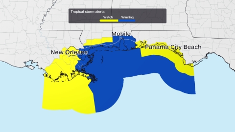
Despite its expected weakening, Bertha will continue to produce hazardous weather across the northern Gulf Coast through at least Thursday. Tropical storm warnings are in effect for coastal Alabama, Mississippi, and far eastern Louisiana, where sustained winds of at least 39 mph are expected. Tropical storm watches remain in place for surrounding coastal areas. Rainfall totals of 2 to 4 inches are forecast across parts of the western Florida Panhandle, southern Alabama, Mississippi, Louisiana, and possibly the Texas coast, while isolated areas could receive up to 6 inches of rain, increasing the risk of flash flooding, particularly in cities such as New Orleans. Strong wind gusts may also cause isolated power outages.
Coastal flooding is another major concern as storm surge is expected to raise water levels by 2 to 4 feet above normal from southeastern Louisiana to the Alabama and Florida border, especially during high tides on Wednesday and Thursday. A storm surge watch has been issued for these areas because life-threatening coastal flooding is possible. In addition, dangerous beach conditions, including rough surf and powerful rip currents, are expected to continue along beaches from the Florida Panhandle to Louisiana through at least Thursday. Residents and visitors are urged to avoid entering the water, as these conditions can be life-threatening even for experienced swimmers.