

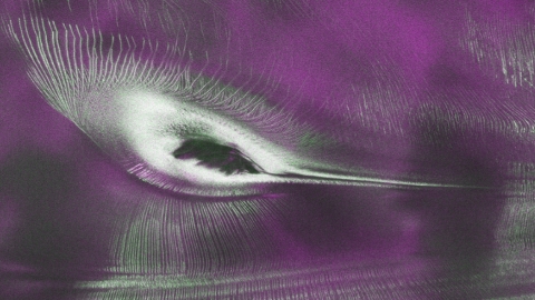
NASA has released a remarkable new image from the NISAR (NASA-ISRO Synthetic Aperture Radar) satellite that reveals a unique hummingbird-like pattern beneath Antarctica’s ice. The image provides scientists with an unprecedented view of glaciers, ice formations, and hidden surface features that cannot be observed with ordinary optical cameras. It was created using data collected by NISAR’s advanced L-band radar during the satellite’s testing phase and highlights the mission’s ability to study Earth’s changing landscapes in extraordinary detail.
Since July 20, researchers and the public have been able to access data from NISAR’s powerful L-band and S-band radar instruments. Scientists in the United States and India are continuing to process and release additional datasets that will support studies of glacier movement, land deformation, forests, wetlands, earthquakes, landslides, and other natural processes. These observations will help improve environmental monitoring and disaster response around the world.
The striking image focuses on Nunatak Zaterjavshijsja, a mountain peak in East Antarctica that rises above a glacier flowing toward the ocean. As the moving glacier passes the mountain, pressure builds within the ice, creating deep cracks known as crevasses. These fractures appear as bright green lines in the radar image and form a pattern that resembles the wings of a hummingbird, making the image both scientifically valuable and visually impressive.
According to NASA engineers, radar technology allows NISAR to see through snow and penetrate deep into the ice, revealing structures that remain hidden in traditional satellite photographs. Unlike optical imagery, which mainly captures the surface, radar can detect changes beneath the ice and provide valuable information about glacier movement, ice thickness, and internal conditions. This capability helps scientists better understand how Antarctica is responding to climate change.
The image’s colours represent how polarised microwave radar signals interact with the ice. Magenta areas indicate smoother ice surfaces where horizontally polarised signals are reflected directly back to the satellite. Green areas show volume scattering, where signals pass through snow and ice or bounce off rough features such as crevasses. White regions represent locations where both types of signals return strongly, suggesting a combination of smooth surfaces and internal scattering. In ordinary optical images, this same landscape appears almost entirely white, with only faint shadows revealing the mountain and surrounding terrain, demonstrating the unique advantages of NISAR’s radar technology.